

ATHENS COUNTY, Ohio — Last September, the Federal Emergency Management Agency sent new flood maps to officials with several Athens County municipalities. The updated maps are the result of a multiyear, sometimes contentious effort between FEMA engineers, local public officials and concerned citizens.
And they can have major implications both for property owners and local governments, especially in smaller communities in low-lying areas.
Officials in Nelsonville and Chauncey have warned that expansions in the regulatory floodway could restrict the potential for development. In Nelsonville’s case, previous city administrations also had warned that new flood maps could affect the future of existing businesses and neighborhoods, as well as potentially reduce the city’s population.
At the same time, though, officials recognize that the maps’ purpose isn’t to stifle development — it’s to keep people and properties safe.
“It’s not like we shouldn’t have these regulations, because it’s stipulating how buildings should be built when they’re very likely to be flooded so that they’re built in a way that won’t harm the structure so much that it’s a total loss, or that it harms neighbors’ houses or something,” said Drew Daniels, Chauncey’s code inspector and floodplain administrator
This is particularly important, he said, as climate change makes extreme weather events more likely.
“With climate change … we’re doing the bare minimum, keeping up with the new maps as they’re drawn,” Daniels said.
What are flood maps?
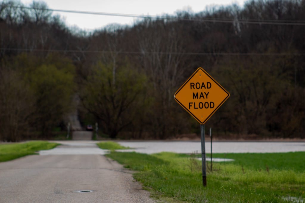
Officially termed Flood Insurance Rate Maps, the maps indicate a property’s flood risk. The most high-risk areas are labeled as Special Flood Hazard Areas. Property owners with federally backed mortgages, such as VA loans, are legally required to carry flood insurance if their property is within a Special Flood Hazard Area. (Renters aren’t required to purchase flood insurance, although FEMA does have a program to insure tenants’ belongings in case of a flood.)
The most restricted areas on the Flood Insurance Rate Maps are those in the regulatory floodway, where new development is prohibited unless an engineering analysis can demonstrate the development won’t increase flood elevations upstream. Improvements to existing structures are allowed in the floodway, so long as those improvements do not increase the value of the structure by more than 50%.
The National Flood Insurance Program offers federally subsidized flood insurance to residents of participating communities; the insurance is not available ala carte. Communities must submit an application to the program, prepare and uphold a floodplain management plan and agree to FEMA’s regulations about development in floodplains.
Athens County, the city of Athens, Nelsonville, and all villages except for Albany participate in the NFIP. (No part of Albany is within a designated flood zone.)
Chauncey was suspended from the program in 2009 for noncompliance issues. As a result, village residents must rely on private insurance — which is much more expensive than premiums through the NFIP.
“It’s really helpful for people to have the subsidized flood insurance, because it’s usually prohibitively expensive or or much more expensive if you’re not getting it subsidized by the government,” said Daniels.
Once accepted into the program — and when flood maps are updated — the community is responsible for enforcing relevant laws and regulations. This often takes the form of permitting, inspections, and construction management.
This can be a challenge for small communities.
“These communities join in, but then you need to have some sort of position to maintain those records, and most of Athens County … there isn’t any sort of code enforcement,” said Daniels.
The problem, he said, is that little assistance is available to support communities in enforcing regulations and weathering their impacts.
“It’s a tricky thing where there needs to be a lot more investment in it, but it’s not really as feasible on a really small scale,” he said.
Nelsonville: Fighting against floodplain expansion
The Athens County flood maps FEMA released in the fall followed a lengthy dispute between FEMA and the city of Nelsonville over preliminary maps for the area first released in 2013, a FEMA spokesperson said.
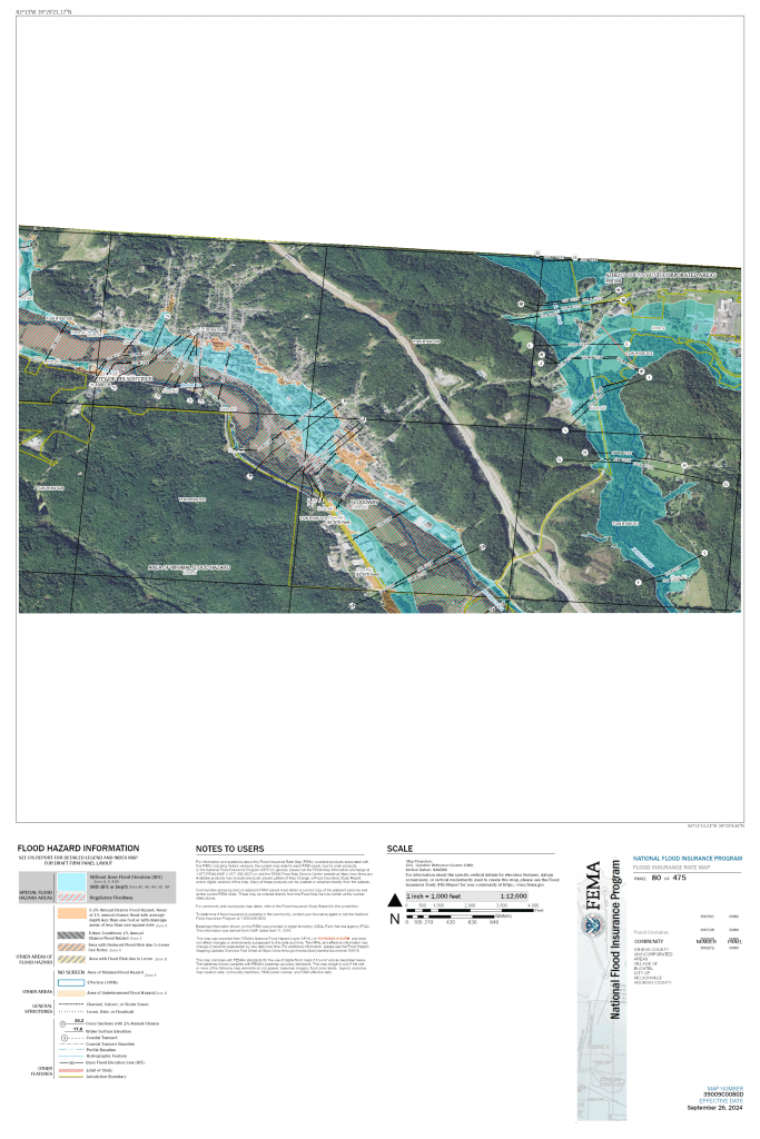
The new maps show a significant expansion of the floodway in the city from the previous edition from 2009, which places many more properties in the floodway. These include homes along Railroad Street, Back Street and Patton Street, as well as the Victorian Village Apartments. The new floodway also cuts through the Appalachian Center for Economic Networks building at 296 S Harper St.
Nelsonville’s interim city manager Devon Tolliver told the Independent in an email that he does not “have enough information to go over the impacts” of the new maps, “especially anything long term.” However, multiple previous city administrations fought FEMA over expansion of the floodway for years.
When FEMA released new maps in 2013, the city filed an appeal of the agency’s decisions. Steve Pierson, who was code director and assistant city manager for Nelsonville at the time the 2013 maps were released, said the change quadrupled the number of parcels in the floodway.
“The appeal was based upon the expansion of the floodway where the mapping at that time had approximately 100 parcels in the floodway and the proposed mapping expanded that to about 400 parcels,” Pierson told the Independent in an email.
The city was concerned about restrictions on new development and on improvements to existing structures in the floodway, Pierson said.
Nelsonville’s appeal prompted FEMA to reevaluate and revise the proposed maps from 2013. That process was completed in 2019, with revised maps issued in 2021. According to a FEMA spokesperson, the revised maps “showed a floodway that addressed key considerations listed in the city’s appeal.”
However, the 2021 maps showed only minor changes from the 2013 proposal, the Athens Messenger reported. The city remained concerned about long-term impacts on future development, existing businesses and homes, and the city population as structures within the flood zone are either demolished or moved (in the case of mobile homes) and cannot be replaced.
The city submitted another appeal, which the FEMA spokesperson said was “related to the placement of a mobile home park in the floodplain/floodway.”
“FEMA conducted a review and consultation for this comment and in early 2023, the information submitted by the city was reflected in an updated version of the maps, which then went effective in September 2024,” the FEMA spokesperson said. “This entire process included numerous calls and meetings with the city and other partners as well as two open houses for the public to learn more about these changes.”
The final maps released by FEMA — in contrast to the 2021 preliminary maps published by the Athens Messenger — show that almost the entirety of the mobile home park near Polley Field was removed from the floodway following the city’s appeal. This doesn’t remove the risk of flooding, it just changes what regulations apply to buildings in the area.
Chauncey: Fighting to get back into NFIP
In Chauncey, Daniels works for the village in a part-time code enforcement position created in 2023, to try to bring the village back into compliance with the NFIP.
Losing access to the NFIP 15 years ago has definitely affected the village, Daniels said.
“Now residents have to get private insurance, not subsidized through FEMA … if they want to have a mortgage or anything,” said Daniels. “Banks can decide to not lend to people who are buying houses in the floodplain, and so it makes it harder for the average person to buy property.”
However, those properties don’t sit empty. People with greater amounts of cash on hand — such as landlords — can buy them up instead.
“Chauncey has changed a lot” since it was suspended, Daniels said.
“It’s more heavily rented properties, rather than owner-occupied properties,” Daniels said. “That’s definitely changed the dynamic of the village.”
Daniels said the village is working to reestablish compliance to benefit village residents — and to encourage future development.
“Getting back into the NFIP would help boost reinvestment into Chauncey, because a larger business is not going to want to go into Chauncey if they can’t get the necessary flood insurance, or if it’s going to be exorbitantly expensive to do so,” Daniels said.
However, establishing compliance with the FEMA floodmaps comes with its headaches.
“It’s not politically very popular to ask for zoning code or floodplain regulations,” Daniels said. “But it is a necessity to be prepared for emergencies, and it’s very awkward tension when you’re trying to talk with residents and explain.”
Less of Chauncey is in the floodplain in the new maps, compared to maps from 2009. But the extent of the regulatory floodway increased substantially: It now encompasses many buildings along Main Street/S.R. 682 and nearby streets.

The changes were proposed for years before taking effect, and that knowledge has already impacted development in Chauncey.
“It’s kind of already started to happen a little bit on the lower end of Chauncey, even before much of it was put into the floodway, where houses that were there have been torn down, and there’s a lot of empty lots, and people haven’t really gone back there to build,” said Daniels.
Additionally, since the new maps came into effect, there have been multiple cases “where we weren’t able to approve repairing structures because it was going to cost more than that 50% threshold and then be subject to the additional requirements in the floodway,” Daniels said.
“I would think that a lot of structures, if they need a lot of work done, won’t have the work done to them,” he added.
Daniels said the village’s work to rejoin the NFIP is “slow going” — and possible only because of investments related to the Baileys Trail in Chauncey, which have made it more possible for the village to secure funding for its various initiatives.

