
ATHENS COUNTY, Ohio — Athens County residents have a new tool to better understand flood risk, thanks to a project led by Rural Action.
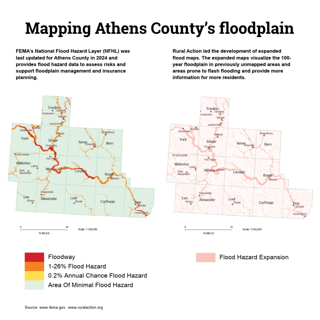
The project expands flood maps for Athens County into areas that did not yet have flood maps available through the Federal Emergency Management Agency. Like the FEMA maps, the Rural Action maps visualize the 100-year floodplain, highlighting areas that have historically flooded on average every 100 years or more.
The FEMA maps, which are available on the Athens County Auditor website and visualize floodplains, do not map all parts of the county and apply only to the floodway surrounding major waterways. The Rural Action maps cover the entire county and map the watershed beyond county boundaries.
Athens County Planner Connor Lavelle told the Independent he believes the Rural Action project will be particularly helpful for residents in more rural areas of the county that didn’t previously have access to accurate flood maps.
“It’s expanding our view of areas that are flood prone and having a better understanding of the flood risk that all of our county is exposed to,” Lavelle said.
Ryan Gilliom, watershed conservation project specialist at Rural Action, said the Rural Action maps take into account flash flood risks beyond major watersheds.
“Rather than being one-dimensional, looking just at the river channel and how that floods, the model we developed looks at the landscape type, the topography, and where flash flooding can occur outside of those main channels,” Gilliom said. “It gives a more complete view of the actual flash flood hazards that are such a big issue here.”
The maps were developed in coordination with the Athens County Planning Office. Like the FEMA maps, the expanded flood maps area are available via the Athens County Auditor’s website. From the main page, viewers can click the maps’ dropdown, select Standard Parcel Viewer, and ensure the maps are viewable via the filter menu. The Rural Action maps are titled “Flood Hazard Expanded,” and the FEMA maps are titled “AC_Flood_Zones.” For an easier viewing experience users may toggle off other layers on the filter menu.
In addition to the county, Gillon said that BSC Group analyzed county topography and climate modelling along with community-submitted information, FEMA maps, and assessments of local vegetation.
Lavelle said the data gathered from the project should enable smarter development in the county moving forward.
For residents and developers, the map can provide a “fuller picture of what is the flood risk that the area that they’re interested in may be exposed to,” Lavelle said. “They can build in a way that both protects their assets, but then also protects that larger environment.”
The data also can help to prevent development in areas that could be damaged by flooding and that could displace floodwaters, impacting areas downstream.
While the Rural Action maps are based on previous flooding, Gilliom noted the 100-year floodplain as shown on the maps does not account for the impacts of human-caused climate change.
The worst-case scenario, Gilliom said, is that current 100-year floods in Athens County could occur every 20 years or so by 2080. However, Gilliom said that, by and large, climate change won’t substantially impact the floodplain boundaries shown on the map.
“When we get more rain at once and have that more intense storm with more intense flooding, because of the landscape we have, we don’t get a bigger floodplain,” Gilliom said. “The water doesn’t expand out wider; it just moves faster with more velocity and force in the places it’s already flooding.”
There are some exceptions to that rule, Gilliom said, noting that some manufactured homes in low-lying parts of the county may be newly vulnerable to floods in the future.
Rural Action also compiled other data as part of its flood hazard assessment, including data on the way in which water moves, as well as data on the 20-year flood risk in the mapped area. More information on the Rural Action project is available on its website.
Residents can request depth and velocity grid data and 20-year floodplain data from the Athens County Planner’s Office by contacting Lavelle’s office at countyplanner@athensoh.org or 740-447-5890.
Lavelle said, “If people have concerns or want to see a particular area of their community, we can help map that out.”
The county planner’s office also is a resource on rules and regulations pertaining to development in the floodplain.
